Twin Peaks 50 Mile- February 12th, 2011- California
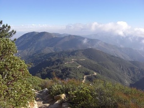
Last minute addition to the race schedule for the year. 50 miles and 17,000 feet of elevation gain in the Cleveland National Forest in Southern California. Really looking forward to the challenge as it's a very similar elevation as Cascade Crest 100 and gets up to about the same total elevation, 6,000 ft.
***UPDATE***Race was reschedule three weeks before the start due to excessive rain in the area that wiped out the FS Roads and access for aid stations. Rescheduled for October 2011...***
***UPDATE***Race was reschedule three weeks before the start due to excessive rain in the area that wiped out the FS Roads and access for aid stations. Rescheduled for October 2011...***
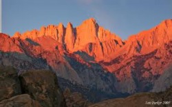
Mt. Whitney, -14,505 ft.
***From Summitpost.com***
Mount Whitney
Page Type: Mountain/Rock
Location: California, United States, North America
Lat/Lon: 36.57860°N / 118.293°W
Elevation: 14505 ft / 4421 m
OverviewMount Whitney, of the California Sierra Nevada, holds numerous distinctions. It is the highpoint of both Tulare & Inyo counties. It is the highest peak in the Sierra, & indeed in all of California. Finally, it rises higher than any piece of land in the United States outside of Alaska.
Mount Whitney's elevation stature continues to intrigue the human psyche, both from a civilian as well as a governmental perspective. Its elevation seems to be continually evaluated and reevaluated using the newest technologies, perpetually changing (usually in an upward trend) the mountain's height. The NPS plaque on the mountain lists Whitney's official height at 14,496.811 feet. The most recent observations by NGS (National Geodetic Survey)/NOAA (National Oceanographic & Atmospheric Administration) put it at 14,505' (4,421m)- thanks Eleutheros!
All this being said, it is still no 5,000m (let alone 6,000 or 7,000m) peak. It would be a minor (if somewhat steep on certain aspects) foothill in any of the Earth’s great ranges. It harbors no glaciers. A huge number of people, possessing little wilderness skills or technical expertise, manage to run, hike, &/or crawl their way to the top of this large piece of exposed granite each year via the uninspiring Mt. Whitney trail.
The attributes which make Mt. Whitney a truly great mountain are frequently overlooked. History, commanding position, excellent rock, its great east face & ‘subsidiary’ needles, & a tantalizing selection of routes are arguably the bread & butter of Mt. Whitney. During the winter months, delightful opportunities also exist for the ski mountaineer / backcountry snowboarder.
While its gentle western slopes would hardly inspire the hardened mountaineer, Whitney’s east face, erupting 2,000 ft. above cold & serene Iceberg Lake, draws the climber’s eye upward & makes them yearn. Whitney’s subsidiary needles, (to the south of the main east face), are awe-inspiring enough by themselves, & have their own epics, legends, & lore firmly established.
The 11-mile Mount Whitney Trail (class 1) is the easiest and most popular route to the summit and is often done as a strenuous 22-mile day hike. During the summer and autumn months, only sneakers are necessary to ascend this summit from the Whitney Portal trailhead at 8,365 feet, however, earlier in the season, an ice axe and crampons may be required. Many people will appreciate taking two days to do this hike, spending a night at Outpost Camp or Trail Camp. An interesting time to visit is the month of April, before the quota season starts, when the snowpack is firmer and Trail Camp becomes a base camp for groups hanging out in the winter alpine scenery using their 2-way radios to talk to those above Trail Crest. While there are many other routes on Whitney, the most popular ones after the main trail include: the Mountaineer's Route, East Face, East Buttress, and North Slope. The first three of these start from Iceberg Lake while the last one is often climbed as a traverse from Mount Russell. Winter makes the Mountaineer's Route a popular objective. The East Face & East Buttress are the classic technical climbs on the peak. For a discussion on winter climbing, see the "When To Climb, Ski, etc." section below.
Getting ThereWHITNEY PORTAL: This is the trailhead for both the Mount Whitney Trail and the Mountaineer's Route as well as many other mountaineering and climbing routes on Mount Whitney, Mount Russell, and Mount Carillon. Take US-395 to Lone Pine and then turn west on Whitney Portal Road. In 13 miles, you will reach Whitney Portal at an elevation of 8,365 feet. Bears have been known to frequent this trailhead so do not leave food in your car during bear season - there's a reason why all the garbage cans are bear-proofed. During winter, the last 6 miles of this road are not plowed. ONION VALLEY: This is primarily a backpacking approach using the Onion Valley traihead reaching Trail Crest in 36.1 miles. The first 7.4 miles cross Kearsarge Pass on the Sierra Crest and bring you to the John Muir Trail (JMT) / Pacific Crest Trail (PCT) where you head south crossing Forester Pass (13180') en route to Mount Whitney via the JMT. You can also bypass Trail Crest on your ascent climbing Mount Whitney's western slopes with a possible camp at Arctic Lake. From norbertc: "Advantages: no crowds, gorgeous scenery along the John Muir trail; no problem getting a last-minute trail permit at Whitney Portal; this is a circuit loop, so when you descend Whitney on the west face you are on that trail for the first time" if you bypass Trail Crest on the ascent. To reach Onion Valley, turn west on US-395 at Independence, north of Lone Pine. OTHER APPROACHS: In addition to Onion Valley, there are numerous other approaches including Horseshow Meadows typically used for Mount Langley (Ref: gordonye). While these other approaches are interesting for backpackers, climbers will usually be interested in a more direct approach. While one may be tempted to bypass the trail quota when using a trailhead other than Whitney Portal, the Whitney Zone covers a large amount of land to the west of Mount Whitney as well, so although this area may not be patrolled by rangers as rigorously, a permit is still required.
Red TapePermits are required year-round, however, a quota is in place for the Mount Whitney Zone from May 1 to November 1 depending whether you are on the Mount Whitney Trial or others, e.g. the Mountaineer's Route (differences described below). Permit information is available on the Inyo National Forest page. During other times, a self-issued wilderness permit is required which can be made at the Mount Whitney Ranger Station in Lone Pine, not at Whitney Portal (see Mountain Conditions section below for the ranger station address). You can also check the Whitney Portal Store Message Board for people who have extra openings on their permits. MOUNT WHITNEY TRAIL: Between May 1 and November 1, there is a quota of 60 overnight hikers and 100 day hikers in effect. 100% of these permits are made available via advanced reservations made during February of the same year (reservations accepted by mail or fax), however permit processing does not begin until February 15. These get taken quickly for weekends and overnights, however, weekday quotas often are not filled. For open slots, permit requests can be made after May 1 (reservations accepted by mail, fax, or phone). Reservations cost $15/person, however, walk-in permits, if any are available, are free. There is now also an explicit "Trail Crest" Exit permit/quota for people who just use the Whitney Trail as a descent route, say for the Mountaineers Route. Luckily for those of us who don't want to bother with quotas, travel between November 2 and April 30 requires only a self-issued wilderness permit. Let's hope it stays that way. OTHER MOUNT WHITNEY ZONE TRAILS (INCL. MOUNTAINEER'S ROUTE): All other trails in the Mount Whitney Zone are also subject to overnight and day quotas between May 1 and November 1, however, only 60% are available via advanced registration with 40% reserved for walk-ins. For the North Fork of Lone Pine Creek (aka Mountaineer's Route), only 10 permits per day are currently available, 6 reservable, and 4 for walk-ins). Use self-issued permits at other times.
When To Climb, Ski, etc.Mount Whitney is a year-round mountain. Between late May and October, hiking/running the Mount Whitney Trail and climbing on the Mountaineer's Route are popular. Then activity generally slackens during the next few months while the snow pack accumulates until the February to early May season when ski mountaineering, backcountry snowboarding, and general mountaineering on routes such as the Mountaineer's Route and the North Face are popular. Mountaineering on the Mount Whitney Trail is also very popular but generally there is not enough good snow above Trail Crest to make this worthy for skiing or boarding. WINTER CONSIDERATIONS While winters in the Sierra are relatively mild, compared to say New Hampshire's Mount Washington and Presidential Range, there are some things to consider:
CampingMOUNT WHITNEY TRAIL: The two popular campgrounds on this trail are Outpost Camp at 10,335' and Trail Camp at 12,000' at 3.8 and 6.2 miles from the trailhead respectively. Those feeling the effects of the altitude will want to stay at Outpost Camp, however, most people making a multi-day trip stay at Trail Camp. During "bear season," you should be prepared for both bears and marmots. In recent years, bears have been known to make it up to Trail Camp so bear-resistant food containers are now required for overnight trips along the Mount Whitney Trail between May 25 and October 31. If you do not have a bear-canister, rangers will ask you to "leave the area." As for marmots, you may want to keep your tent pinned down with rocks and leave it open along with your pack so they won't feel compelled to chew through your gear to satisfy their curiosity. NORTH FORK OF LONE PINE CREEK: The popular campgrounds along this route are: Lower Boy Scout Lake (10,300'), Upper Boy Scout Lake (11,350'), and Iceberg Lake (12,600'). Many parties climbing the Mountaineer's Route and other East Face routes in 2+ days will try to reach Iceberg Lake on the first day. All camping should be at least 100 feet from the lakes. Human waste should be buried 6-8 inches deep and at least 200 feet (70 paces) from any campsite and water source. Toilet paper should be packed out. According to the Inyo NF, "Improper disposal of human waste at Iceberg Lake is a serious problem." Proper water treatment is probably a good idea here!
Mountain ConditionsUse the following resources to check route and weather conditions on Mount Whitney: www.395.com - High Sierra Weather Report incl. satellite photo.
Weather Underground - Lonepine, CA Weather Forecast
Whitney Portal Store Message Board
CSAC Eastern Sierra Avalanche Bulletin MOUNT WHITNEY RANGER STATION
P.O. Box 8
Lone Pine, CA 93545
(760) 876-6200
(760) 876-6201 TDD
website
Open 7 days/week; 8.00 - 17.00 Nov - Apr, 8.00 - 18.00 May - Oct
At the 'Interagency Visitor Center' 1 mi S of Lone Pine, US 395-State route 136 junction
Whitney, The ManCharley Begole, Johnny Lucas & Al Johnson took a trip to the summit of the highest mountain in the range, & christened it ‘Fisherman’s Peak.’ Ain’t it as romantic as ‘Whitney?’ The fishermen who found it looked mighty romantic on their return to Soda Springs. Wonder who that old earthquake sharp thinks is running this country, anyhow?
-Inyo Independent, 20 September, 1873
For years our chief, Professor Whitney has made brave campaigns into the unknown realm of Nature. Against low prejudice & dull indifference he has led the survey of California onward to success. There stand for him two monuments, - one a great report made by his own hand; another the loftiest peak in the Union, begun for him in the planet’s youth & sculptured of enduring granite by the slow hand of Time.
-Clarence King
The appellation of what is now known as Mt. Whitney stands as testimony to the rewards of shameless brown-nosing, before the United States Geological Survey (USGS) introduced naming guidelines designed to prevent such shameless & juvenile acts from occurring.
Despite Clarence King's amusing inability to be the first to scale this great peak (the highest in the contiguous United States, no doubt a large contributor to his desire to be the first ascentionist), his boss happened to be Josiah Whitney (1819-1896). Whitney happened to be chief of the California State Geological survey at the time. As Whitney kept on approving the paperwork funding yet one failed expedition to summit the mountain after another for his obsessed henchman King, King felt compelled to express his gratitude in a meaningful manner. Mt. Whitney thus became Mt. Whitney after King & Richard Cotter dubbed it as such in July, 1864 (fittingly from the top of Mt. Tyndall).
A person of modern times could not be blamed for being curious about how Joshiah Whitney became the state’s head geologist (1864-1874), as well as professor of geology at Harvard (1869-1896). Whitney, despite his academic qualifications, held various misperceptions commonly known today to be falsities. He denied the possibility of any active glaciers remaining in the lower 48 states; ironically enough, King named one of the first documented glaciers that he ‘discovered’ (& California’s largest, on the northern flanks of Mt. Shasta) after Whitney). Whitney was also adamant in his denial of Yosemite Valley’s formation by glacial movement (it was indeed formed by glaciers), a concept proposed by the great naturalist & conservationist John Muir, whom Whitney scornfully referred to as ‘that shepherd.’ Interestingly enough, a subsidiary peak of Mt. Whitney, lying a short distance south of the true summit bears Muir’s name.
Mount Whitney
Page Type: Mountain/Rock
Location: California, United States, North America
Lat/Lon: 36.57860°N / 118.293°W
Elevation: 14505 ft / 4421 m
OverviewMount Whitney, of the California Sierra Nevada, holds numerous distinctions. It is the highpoint of both Tulare & Inyo counties. It is the highest peak in the Sierra, & indeed in all of California. Finally, it rises higher than any piece of land in the United States outside of Alaska.
Mount Whitney's elevation stature continues to intrigue the human psyche, both from a civilian as well as a governmental perspective. Its elevation seems to be continually evaluated and reevaluated using the newest technologies, perpetually changing (usually in an upward trend) the mountain's height. The NPS plaque on the mountain lists Whitney's official height at 14,496.811 feet. The most recent observations by NGS (National Geodetic Survey)/NOAA (National Oceanographic & Atmospheric Administration) put it at 14,505' (4,421m)- thanks Eleutheros!
All this being said, it is still no 5,000m (let alone 6,000 or 7,000m) peak. It would be a minor (if somewhat steep on certain aspects) foothill in any of the Earth’s great ranges. It harbors no glaciers. A huge number of people, possessing little wilderness skills or technical expertise, manage to run, hike, &/or crawl their way to the top of this large piece of exposed granite each year via the uninspiring Mt. Whitney trail.
The attributes which make Mt. Whitney a truly great mountain are frequently overlooked. History, commanding position, excellent rock, its great east face & ‘subsidiary’ needles, & a tantalizing selection of routes are arguably the bread & butter of Mt. Whitney. During the winter months, delightful opportunities also exist for the ski mountaineer / backcountry snowboarder.
While its gentle western slopes would hardly inspire the hardened mountaineer, Whitney’s east face, erupting 2,000 ft. above cold & serene Iceberg Lake, draws the climber’s eye upward & makes them yearn. Whitney’s subsidiary needles, (to the south of the main east face), are awe-inspiring enough by themselves, & have their own epics, legends, & lore firmly established.
The 11-mile Mount Whitney Trail (class 1) is the easiest and most popular route to the summit and is often done as a strenuous 22-mile day hike. During the summer and autumn months, only sneakers are necessary to ascend this summit from the Whitney Portal trailhead at 8,365 feet, however, earlier in the season, an ice axe and crampons may be required. Many people will appreciate taking two days to do this hike, spending a night at Outpost Camp or Trail Camp. An interesting time to visit is the month of April, before the quota season starts, when the snowpack is firmer and Trail Camp becomes a base camp for groups hanging out in the winter alpine scenery using their 2-way radios to talk to those above Trail Crest. While there are many other routes on Whitney, the most popular ones after the main trail include: the Mountaineer's Route, East Face, East Buttress, and North Slope. The first three of these start from Iceberg Lake while the last one is often climbed as a traverse from Mount Russell. Winter makes the Mountaineer's Route a popular objective. The East Face & East Buttress are the classic technical climbs on the peak. For a discussion on winter climbing, see the "When To Climb, Ski, etc." section below.
- Routes Overview Route Name Difficulty FA FA Party Cardiovascular Seizure III 5.10 1973 Vern Clevenger & Keith Bell East Buttress III 5.8 1937 Bob Brinton, Glen Dawson, Richard Jones, Howard Koster, & Muir Dawson East Face III 5.6 1931 Robert Underhill, Glen Dawson, Jules Eichorn, & Norman Clyde Direct Crack Variation 5.8 1953 John Medenhall McKusky Variation 5.6 1996 Patrick McKusky, Tony Padilla, & Jeremy Georgelos Shaky-Leg Crack Variation 5.7 1936 Morgan Harris, James N. Smith, & Neil Ruge Ortenburger Variation ? ? ? Direct East Face V 5.9 A3 or 5.10d 1959 Denis Rutovitz & Andrzel Ehrenfeucht Great Book, The IV 5.9 1974 Gary Colliver & Chris Vandiver Hairline V 5.10 C2F or A2 1987 Bruce Bindner & Alex Schmauss Left Wing Extremist V 5.11a 1991 Galen Rowell & David Wilson Mountaineer's Route Class 3 1873 John Muir North Slope Class 2-3 ? ? Northeast Ridge III 5.10 1982 Galen Rowell, Glaude Fiddler, & Vern Clevenger Northwest Rib 5.7 1988 Galen Rowell Peewee's Big Adventure III 5.9 1986 Joel Richnak & Mark Carville Rotten Chimney, The III 5.8 1973 Vern Clevenger, Mark Moore, & Julie X Southeast Face III Class 5 1941 John Mendenhall & Ruth Mendenhall West Slope Class 2 1873 Charles Begole, Albert Johnson, & John Lucas Whitney-Keeler Couloir Class 5 A? 1964 Jim Servais & John Mendenhall Whitney Trail, The Class 1 ? ? Map Name Publisher Scale Interval Plastic Lat/Long UTM Mount Whitney USGS 1:24,000 ? N ? ? Mt. Whitney High Country Trail Map Tom Harrison Maps 1:63,000 80 ft Y Y Y Sequoia & Kings Canyon National Parks Recreation Map Tom Harrison Maps 1:125,000 200 ft Y Y Y Sequoia/Kings Canyon National Park Trails Illustrated 1:111,850 ? Y Y ?
Getting ThereWHITNEY PORTAL: This is the trailhead for both the Mount Whitney Trail and the Mountaineer's Route as well as many other mountaineering and climbing routes on Mount Whitney, Mount Russell, and Mount Carillon. Take US-395 to Lone Pine and then turn west on Whitney Portal Road. In 13 miles, you will reach Whitney Portal at an elevation of 8,365 feet. Bears have been known to frequent this trailhead so do not leave food in your car during bear season - there's a reason why all the garbage cans are bear-proofed. During winter, the last 6 miles of this road are not plowed. ONION VALLEY: This is primarily a backpacking approach using the Onion Valley traihead reaching Trail Crest in 36.1 miles. The first 7.4 miles cross Kearsarge Pass on the Sierra Crest and bring you to the John Muir Trail (JMT) / Pacific Crest Trail (PCT) where you head south crossing Forester Pass (13180') en route to Mount Whitney via the JMT. You can also bypass Trail Crest on your ascent climbing Mount Whitney's western slopes with a possible camp at Arctic Lake. From norbertc: "Advantages: no crowds, gorgeous scenery along the John Muir trail; no problem getting a last-minute trail permit at Whitney Portal; this is a circuit loop, so when you descend Whitney on the west face you are on that trail for the first time" if you bypass Trail Crest on the ascent. To reach Onion Valley, turn west on US-395 at Independence, north of Lone Pine. OTHER APPROACHS: In addition to Onion Valley, there are numerous other approaches including Horseshow Meadows typically used for Mount Langley (Ref: gordonye). While these other approaches are interesting for backpackers, climbers will usually be interested in a more direct approach. While one may be tempted to bypass the trail quota when using a trailhead other than Whitney Portal, the Whitney Zone covers a large amount of land to the west of Mount Whitney as well, so although this area may not be patrolled by rangers as rigorously, a permit is still required.
Red TapePermits are required year-round, however, a quota is in place for the Mount Whitney Zone from May 1 to November 1 depending whether you are on the Mount Whitney Trial or others, e.g. the Mountaineer's Route (differences described below). Permit information is available on the Inyo National Forest page. During other times, a self-issued wilderness permit is required which can be made at the Mount Whitney Ranger Station in Lone Pine, not at Whitney Portal (see Mountain Conditions section below for the ranger station address). You can also check the Whitney Portal Store Message Board for people who have extra openings on their permits. MOUNT WHITNEY TRAIL: Between May 1 and November 1, there is a quota of 60 overnight hikers and 100 day hikers in effect. 100% of these permits are made available via advanced reservations made during February of the same year (reservations accepted by mail or fax), however permit processing does not begin until February 15. These get taken quickly for weekends and overnights, however, weekday quotas often are not filled. For open slots, permit requests can be made after May 1 (reservations accepted by mail, fax, or phone). Reservations cost $15/person, however, walk-in permits, if any are available, are free. There is now also an explicit "Trail Crest" Exit permit/quota for people who just use the Whitney Trail as a descent route, say for the Mountaineers Route. Luckily for those of us who don't want to bother with quotas, travel between November 2 and April 30 requires only a self-issued wilderness permit. Let's hope it stays that way. OTHER MOUNT WHITNEY ZONE TRAILS (INCL. MOUNTAINEER'S ROUTE): All other trails in the Mount Whitney Zone are also subject to overnight and day quotas between May 1 and November 1, however, only 60% are available via advanced registration with 40% reserved for walk-ins. For the North Fork of Lone Pine Creek (aka Mountaineer's Route), only 10 permits per day are currently available, 6 reservable, and 4 for walk-ins). Use self-issued permits at other times.
When To Climb, Ski, etc.Mount Whitney is a year-round mountain. Between late May and October, hiking/running the Mount Whitney Trail and climbing on the Mountaineer's Route are popular. Then activity generally slackens during the next few months while the snow pack accumulates until the February to early May season when ski mountaineering, backcountry snowboarding, and general mountaineering on routes such as the Mountaineer's Route and the North Face are popular. Mountaineering on the Mount Whitney Trail is also very popular but generally there is not enough good snow above Trail Crest to make this worthy for skiing or boarding. WINTER CONSIDERATIONS While winters in the Sierra are relatively mild, compared to say New Hampshire's Mount Washington and Presidential Range, there are some things to consider:
- Climbing Gear: Generally snowshoes, crampons, and an mountaineering axe are required. Expect to use snowshoes on the lower portions of the trail through March/April as you may encounter several feet of fresh snow along the trail, however they may no longer be necessary by late April to May. On the Whitney Trail expect to change over to crampons and axe by the time you hit Trail Crest and above though windpacked snow should begin just above Bighorn Park (outside of the trees). On the Mountaineers Route, you will need an axe and crampons above the notch. Often times rope is used on the last section of the Mountaineers Route to gain the Whitney Plateau.
- Sleeping Gear (Mostly Ref: Gonekuku): Given the Sierra's generally mild weather, you should be fine preparing for a -20°F night though some people go as light as 0°F. Night temps at 12,000' can range from 5°F to -10°F. It's useful to use the "aviation rule" for temperatures: "You lose about 3.6°F per 1,000 feet gained. If it's 40°F low at Lone Pine, it's about 36°F colder on the summit of Whitney that night. (about 7°F at trail camp)." Day temps at Outpost Camp have been reported in the 8-9°F range.
- Approach: During heavy snow, the Whitney Portal Road is closed at either at the Lone Pine Campground (5,900') or the base of the mountain (6,600'). There is no plowing beyond 6,600' and people often park on the north side of the road here. If you take a 4WD vehicle past the plowed area, be aware that your vehicle can get stuck in snow storms or rock slides. During the winter, many groups make their first camp at Whitney Portal (8,365').
- Avalanche Conditions: While the Whitney Trail does not have any recent history of avalanche danger, you should still check the CSAC Avalanche Bulletin (under Mountain Conditions section).
CampingMOUNT WHITNEY TRAIL: The two popular campgrounds on this trail are Outpost Camp at 10,335' and Trail Camp at 12,000' at 3.8 and 6.2 miles from the trailhead respectively. Those feeling the effects of the altitude will want to stay at Outpost Camp, however, most people making a multi-day trip stay at Trail Camp. During "bear season," you should be prepared for both bears and marmots. In recent years, bears have been known to make it up to Trail Camp so bear-resistant food containers are now required for overnight trips along the Mount Whitney Trail between May 25 and October 31. If you do not have a bear-canister, rangers will ask you to "leave the area." As for marmots, you may want to keep your tent pinned down with rocks and leave it open along with your pack so they won't feel compelled to chew through your gear to satisfy their curiosity. NORTH FORK OF LONE PINE CREEK: The popular campgrounds along this route are: Lower Boy Scout Lake (10,300'), Upper Boy Scout Lake (11,350'), and Iceberg Lake (12,600'). Many parties climbing the Mountaineer's Route and other East Face routes in 2+ days will try to reach Iceberg Lake on the first day. All camping should be at least 100 feet from the lakes. Human waste should be buried 6-8 inches deep and at least 200 feet (70 paces) from any campsite and water source. Toilet paper should be packed out. According to the Inyo NF, "Improper disposal of human waste at Iceberg Lake is a serious problem." Proper water treatment is probably a good idea here!
Mountain ConditionsUse the following resources to check route and weather conditions on Mount Whitney: www.395.com - High Sierra Weather Report incl. satellite photo.
Weather Underground - Lonepine, CA Weather Forecast
Whitney Portal Store Message Board
CSAC Eastern Sierra Avalanche Bulletin MOUNT WHITNEY RANGER STATION
P.O. Box 8
Lone Pine, CA 93545
(760) 876-6200
(760) 876-6201 TDD
website
Open 7 days/week; 8.00 - 17.00 Nov - Apr, 8.00 - 18.00 May - Oct
At the 'Interagency Visitor Center' 1 mi S of Lone Pine, US 395-State route 136 junction
Whitney, The ManCharley Begole, Johnny Lucas & Al Johnson took a trip to the summit of the highest mountain in the range, & christened it ‘Fisherman’s Peak.’ Ain’t it as romantic as ‘Whitney?’ The fishermen who found it looked mighty romantic on their return to Soda Springs. Wonder who that old earthquake sharp thinks is running this country, anyhow?
-Inyo Independent, 20 September, 1873
For years our chief, Professor Whitney has made brave campaigns into the unknown realm of Nature. Against low prejudice & dull indifference he has led the survey of California onward to success. There stand for him two monuments, - one a great report made by his own hand; another the loftiest peak in the Union, begun for him in the planet’s youth & sculptured of enduring granite by the slow hand of Time.
-Clarence King
The appellation of what is now known as Mt. Whitney stands as testimony to the rewards of shameless brown-nosing, before the United States Geological Survey (USGS) introduced naming guidelines designed to prevent such shameless & juvenile acts from occurring.
Despite Clarence King's amusing inability to be the first to scale this great peak (the highest in the contiguous United States, no doubt a large contributor to his desire to be the first ascentionist), his boss happened to be Josiah Whitney (1819-1896). Whitney happened to be chief of the California State Geological survey at the time. As Whitney kept on approving the paperwork funding yet one failed expedition to summit the mountain after another for his obsessed henchman King, King felt compelled to express his gratitude in a meaningful manner. Mt. Whitney thus became Mt. Whitney after King & Richard Cotter dubbed it as such in July, 1864 (fittingly from the top of Mt. Tyndall).
A person of modern times could not be blamed for being curious about how Joshiah Whitney became the state’s head geologist (1864-1874), as well as professor of geology at Harvard (1869-1896). Whitney, despite his academic qualifications, held various misperceptions commonly known today to be falsities. He denied the possibility of any active glaciers remaining in the lower 48 states; ironically enough, King named one of the first documented glaciers that he ‘discovered’ (& California’s largest, on the northern flanks of Mt. Shasta) after Whitney). Whitney was also adamant in his denial of Yosemite Valley’s formation by glacial movement (it was indeed formed by glaciers), a concept proposed by the great naturalist & conservationist John Muir, whom Whitney scornfully referred to as ‘that shepherd.’ Interestingly enough, a subsidiary peak of Mt. Whitney, lying a short distance south of the true summit bears Muir’s name.
California 50K & Marathons
Western States 100, Way Too Cool 50K, Bulldog 50K....there are hundreds of them.