|
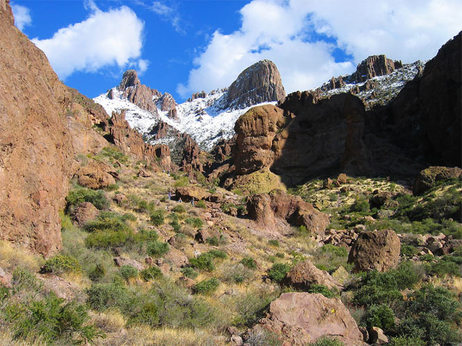
There is quite a bit to catch up on here. First I'll start with the Aspen trip with the guys to circumnavigate the Maroon Bells-Snowmass Area. Three days, 30 miles, 7 guys, 4 passes through the Rockies getting up to 12,400+ four seperate times. Simply incredible country. Too many people for me as you never really felt "alone" out there despite the massiveness and openess of the wilderness. Very little wildlife. Little even in the way of birds which we all throught was strange. First day was really rough with my head being affected by the 10,000+ in altitude that I'm not used to. We kicked up one long climb to the first pass and then camped that night in a bowl on the other side. Hit 19 degrees that night and we all froze. Second day was a two pass day with the first pass being fairly easy. Dropped down into another valley and had some great single track through some pine forest as we decended back below tree line. That was followed by an EPIC climb up the third pass. This took us from under 10,000 feet to up over 12,500 ft in about 4 miles. The climb continued on and on relentlessly it seemed with one false summit after another. Noah, Clint and I made it all the way up first in the group to get the view of Snowmass Lake in the "new" valley below. Views in all directions were simply incredible. Decended down to Snowmass for a much warmer night at camp (30 degrees) before hiking back out the last pass and down the long decent to the first lakes and our cars. All in all...amazing.
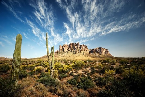
The following Saturday I took a solo trip out to First Water Trailhead in the Supersition Wilderness. EARLY. Wanted to test out a 15-20 mile route along the Dutchman Trail. Right away this trail was verging on magazine worthy with the bedrock trail lined with massive rocks, rock walls, and canyon walls. Following along rivers as it climbs one small hill after another revealing one canyon or valley after another. Weever's Needle was in plain view the first few miles before breaking off to a secondary trail. Down Bull Run and along the Dutchman Trail again where it was clear nobody had been in several months. No trails, no footprints, no sign of humans in some time. The trail was overgrown with catclaw and cactus which was a non stop battle as I crashed through along the trail. I turned around about 8 miles into the morning knowing I was going back a slightly longer way. The trail was amazing minus the overgrowth but that overgrowth is expected after a long hot summer keeping the hikers away. Coming back to the truck I counted a total of 24 river beds I crossed with all 24 being bone dry. This would be an interesting run in the winter with flowing rivers for sure. I saw one person about 4 miles away from the parking lot hiking but otherwise nobody until I was in the parking lot itself. Really, really hot and exposed on the last few miles as I as out there past 9am and into the upper 90's. Back at the truck my legs, chest and arms were a bloody mess and had the look of a horror flick there was so much blood and cuts in so many directions. The shower wasn't pretty but they were all just scratches. I took some amazing photos (posted under Superstition Wilderness) of the trail itself. Better weather (reoccuring sentiment) and I'm going back for the full loop to Peralta and back. Finally, this morning i did a 17 mile run through the McDowell Mountain Regional Park with Honey, Paulette, and Paul. Had a great time talking to everyone and hitting some great single track. Lot's of climbing (3,700+ ft total up, same down) up Bell Pass and Tom's Thumb and just as much running down. My La Sportiva Crosslites are completely whipped and caused my legs to be gassed about 13 miles in. There is just no supportive traction on the bottoms anymore and I can easily feel every rock and every step feels like a jarring sensation through my legs. Then the heat came in and the 90+ degrees started sapping my energy even more. Luckily the heat was killing everyone else and we walked in the last full mile. I was ok with it as we were out there for 4.5 hours. I tried out my new 100oz Nathan's running pack for the first time with the dual hydration bladders to drink water or pedialyte along the course. Awesome. I could have played basketball in that pack it was so comfortable. We also saw a desert tortoise on the top of the ridge by Toms Thumb. Pretty cool.
0 Comments
Resting heart rate in the 30's? I give up. Just watch and sit back in amazement. Oh and he's 22 years old... Killian Journet is a freak of nature. The kid can run forever and at a pace I'm doing a 10K. It's simply incredible. He's sponsored by Salomon and the put together these videos which are really well done. He has about a dozen of these from his trip through the Pyrennes in 7 days this year and the Corsicas. He's attempting to break the record this fall in summitting Mt. Kilamenjaro (spelling?).
This video fo the CCC race in France is simply incredible. It embodies every reason everyone runs these races. I love it.
I've been spending some time looking over the maps of the Superstition Wilderness Area in eastern Phoenix area and have been working on finding a runable route through some of the most beautiful mountains, canyons and desert in Arizona. Originally I was looking for a route similar to a Siphon Draw>Ridgeline>Peralta back to the car route but that is likely to be more route finding than running. This may be fun at its 22-23 miles and 4,800 feet in elevation gain, especially starting out with the big, rugged climb up the Flatiron. But as it will likely lead to more route finding and overgrown trail a more used trail is more in tune with an actual run.
Which brings me to option #2. Starting at the First Water Trailhead jump on the 17 mile Dutchman Trail, follow to 103 (1.5 miles), 3.4 miles along the 239 taking you back to the Dutchman Trail. Follow the Dutchman back down the ridgeline to the Peralta Trailhead where it climbs back up the mountain and meets with the Dutchman and Black Mesa Trails. Take the Black Mesa trail back down to the Second Water Trail, hand a left back the last mile or so to a return to the First Water Trail trailhead. It's probably between 4,000-6,000 ft in elevation gain and it's 31 miles give or take. I have to verify it on the maps again when I break out the paper maps. It keeps the run from being a shuttle and remains on the more popular trails so hopefully it is not too reliant on trail finding and more on trail running. Either way I'm ready to give it a shot. Need to verify any potential water options along the way if any, maybe even a refill at the Peralta Traihead which would be IDEAL. I've never been to that lot so not sure if they have a fountain or anything. Considering its a top hike in all of AZ I'm imagining some kind of facilities. Maybe September we can get out there and try it?? More to come later. Going out for a 20 miler tomorrow in PMP. Hoping to get that many in at least. 3-4 hours is my range. We'll see how it goes. |
Archives
September 2019
Categories
All
|


